Researchers are tagging and acoustically tracking migrating fish in the Murray-Darling Basin to recover our native fish populations and revive our rivers.
The Murray-Darling Basin is the drainage basin for six of Australia’s longest rivers, and covers most of New South Wales and Victoria, parts of both Queensland and South Australia and the Australian Capital Territory. Water drawn from the Basin supports more than 40 per cent of Australia’s agriculture production by value. From the time of European settlement, the Murray-Darling Basin has seen the construction of dams and weirs, with extensive regulation, diversion and extraction of water. Every drop of water going downstream now has a recognised owner and an allocated purpose, and there is only ever ‘surplus’ water during major flood events.
Despite water being the lifeblood of the region, flows have become incredibly disconnected among rivers due to dams and weirs. Many rivers have experienced decreased runoff, intermittent flows and more ‘ponded’ weir pools, making them increasingly disconnected from their tributaries and floodplains. Depending on the demand for water at particular places and times, river height may vary by up to 50 per cent of the channel depth over the course of a single day, and when there is no demand for irrigation water, flows are often turned off and entire channels can run dry.
The loss of dynamic and seasonal water flows, increase in no-flow periods and periodic disconnection of tributaries, streams, pools and lowland floodplains has had consequences for the natural environment, and the various habitats it affords the creatures living in it.
Particularly fish. Native fish populations in the Murray-Darling Basin have declined by over 90 per cent since European settlement.
The Murray-Darling Basin Authority has implemented the Basin Plan to manage water resources in the national interest, which includes improving ecological conditions and protecting habitats. The environment is represented by the Commonwealth Environmental Water Holder (CEWH) as the single largest ‘owner’ of water in the Basin, and it is responsible for providing ‘environmental flows’ to provide ecological benefits along the 2,000 km Murray River to the sea in South Australia. Even with environmental flows reinstated, many of our native fish populations are in a perilous state.
The question then becomes “what environmental flows – when, where, how much and how often – do our fish actually need to thrive, and repopulate across the breadth of the Basin?”
It is a question that has intrigued Dr Ivor Stuart, Associate Professor of Fisheries at the Gulbali Institute, Charles Sturt University, for the last 30 years. “There are a lot of different interconnected issues caused largely by dams and weirs, but the biggest issue we’re tackling is restoring connected flow pathways for migratory fish,” he explains.
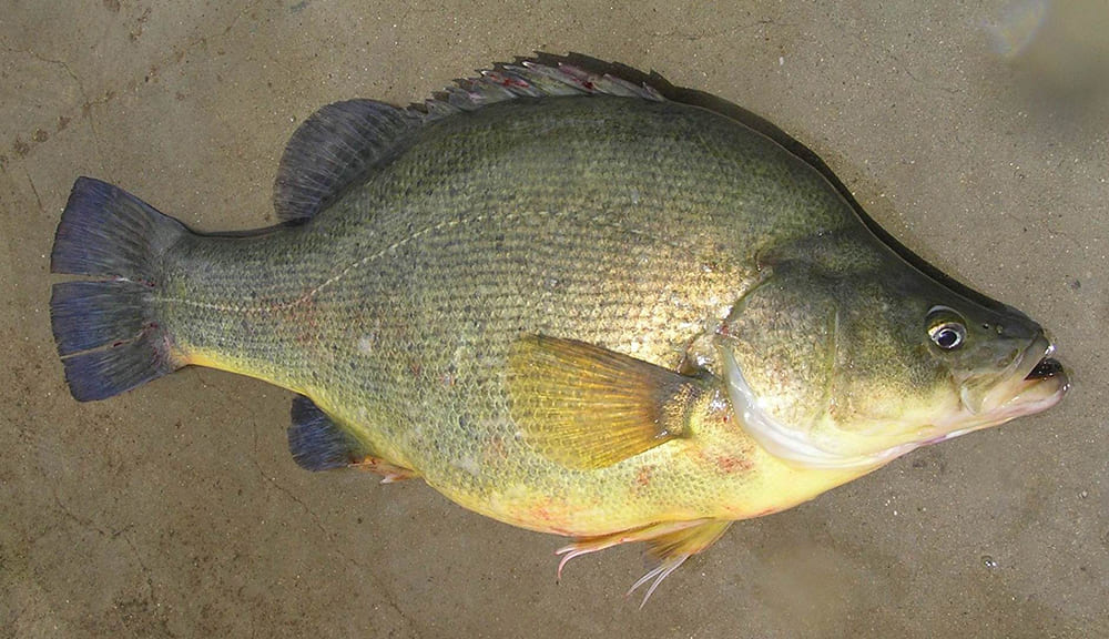
Migratory fish are most affected by changed water flow conditions in the Murray-Darling Basin, as they move between different habitats many times over the course of their lives, for spawning, feeding and growing. The indicator species Dr Stuart is focusing on is the golden perch, a medium-sized (3 kg), long-lived (more than 20 years), highly migratory fish that used to be prevalent across the Basin, but which is now contracted to fragmented populations in the more unregulated regions.
Research areas: native fish population management, environmental recovery
Research problem: tracking golden perch movement across its early life cycle and its migratory response to environmental water flows
Collaborators/countries: NSW Department of Climate Change, Energy, the Environment and Water, Commonwealth Environmental Water Holder, NSW Department of Primary Industries and Regional Development
Outcomes: multi-year environmental water flow strategies to coordinate spawning, dispersal and recruitment of native fish populations across the Murray-Darling Basin
Impact: improved dispersal and resilience of native fish populations, improved health of riverine ecosystems in the Murray-Darling Basin
Beneficiaries: fish populations and the natural environment, while still enabling water access for other users across the Basin
“In a sense, the golden perch are emblematic of all of the other native fish in the Basin,” explains Dr Stuart. “If we can get the conditions right for golden perch to survive, a highly mobile animal with a complex life history, it will also benefit the rest of the fish community with simpler life histories and more limited ranges.”
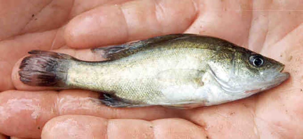
Seasonal water flow pulses, together with seasonal temperature changes, prompt golden perch to migrate and spawn every year. Their eggs passively drift with the water flow, eventually migrating their larvae into floodplain nursery habitats downstream that support juvenile growth. The survival of larvae and juveniles each year is closely linked to high flows or flood conditions, giving rise to age-related cohorts of fish associated with specific floodplain connection events. The riverine spawning habitats, long-distance drift and floodplain nursery habitats for juvenile fish, such as the Menindee Lakes, are now being recognised.
However, new technology developments and an environmental crisis have provided an opportunity for Dr Stuart to track the early life cycle of the golden perch.
After three years of drought and long periods of zero-flow conditions in the Barwon-Darling River, rainfall in the northern and eastern parts of the Basin brought drought-breaking flows in the catchment in 2020. The NSW Government protected these flows from water extraction to help the region’s highly stressed riverine ecosystems and fish populations recover. The conditions provided an opportunity for a collaborative research team from Charles Sturt University and NSW Department of Primary Industries and Regional Development to measure the timing and extent of spawning in response to the rare long-distance flow event.
“We had to resort to otolith chemistry and genetic techniques to identify and measure the age of individual larvae,” explains Dr Stuart. “Otoliths are bony structures found in the inner ear, and they accumulate layers of calcium carbonate as the larvae and fish grow. You can count the layers to measure the larvae’s age, similar to counting tree rings.”
Golden perch larvae were captured at sampling sites across more than 1,600 km of the Barwon-Darling River and three of its major tributaries, with their size and age distributions indicating spawning had occurred in both the mainstream river and the tributaries, with the flow then dispersing larvae hundreds of kilometres down into the Menindee Lakes.
“From this tracking work, and the fish surveys we undertake every year, we now know where the golden perch spawn, how they connect to the nurseries, and can see that strong year-cohorts of young fish are associated with floods,” says Dr Stuart. We need significant flow events, and connected river systems spanning 500–1,000 km to waterholes and floodplains to ensure widespread spawning, and juvenile survival.”
Dr Stuart and his team have subsequently tracked the dispersal of juvenile golden perch from the Menindee Lakes further downstream into the lower Darling-Baaka River and the connected Murray River system. “Some of these juvenile fish travel over a thousand kilometres,” he reflects. “Many of the adults spawn in the northern reaches of the Darling River towards Queensland. Eggs and larvae drift down through the Menindee Lakes, down through the lower Darling-Baaka River, growing larger, and then they disperse into the Murray River.”
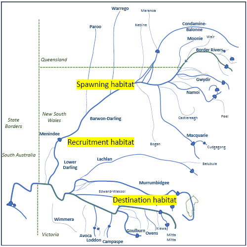
Dr Stuart is now trying to identify the flow cues for dispersing juvenile fish into longer-term receiving tributary and mainstem Murray habitats that provide shelter and food. “We know that a year after the flood, these juveniles are on the move, but we previously never knew where these fish went, or why.”
By tagging and acoustically tracking these migrating fish, researchers from Charles Sturt University and NSW Department of Climate Change, Energy, the Environment and Water, with funding from CEWH, are slowly identifying how dispersing fish spread into the Murray River and tributaries like the Murrumbidgee and Edward-Wakool systems where fish might stay a year or two and mature, alongside adult fish making return visits to these supportive habitats. “We’re starting to work out which locations the fish are targeting in response to environmental flows and connected habitats, what attracts juvenile fish back into the mid and upper reaches of the Murray system.”
It's all building a picture of how environmental water flows can best be managed to support both spawning migrations, and the dispersive migrations of young fish. “For example, if we have a flood event, where fish spawn and survive, we know where we need to support environmental water flows in specific tributaries a year later to enable these juvenile fish to get where they want to go and continue their life journey.”
It's a global-stage migration for these fish, as Dr Stuart points out: “We’re seeing 2,000–3,000 km journeys for some of these fish by the time they’re three years old. And although efforts to track movements of these fish began in the 1970s, we’re only now filling in the blanks on the crucial first year of their lives, and the river conditions and habitats they need to survive past that, so they can mature enough to head back upstream and spawn themselves.”
It's information that all feeds into environmental water planning for the Murray-Darling Basin to better coordinate multi-year water flows across catchments, communities and states to recover our native fish populations and revive our rivers.